Not A Moment’s Rest
Finlayson Arm 50 km Race Report
Despite the immense beauty, rugged terrain and innumerable mountain trails here on Vancouver Island, there has been a notable shortage of ultradistance races. I am aware of two ultras – The Great Walk (63.5 km of gravel logging road) and Elk/Beaver Ultra (5 or 10 loops of a 10 km flat, lakeside trail). This dearth of mountain trail ultra races is not a reflection of the ultra running community since each weekend, ferry loads of local racers sail to the mainland to satisfy their race appetites. Luckily, this year, two more Island trail ultras appeared on the radar but unfortunately only 6 days separated them. Although I wanted to support them both, I chose to register for Finlayson Arm 50 km which would round out my season of ultra races. The Snowden Trail Challenge will have to wait one more year.
The Finlayson Arm 50 km is essentially an out-and-back course with an extra loop tacked onto the front end and a gracious skirting of Mt Finlayson’s rocky summit on the return trip. Mt Finlayson is a large rocky knob just a little north and a little west of Victoria BC. As we drove towards Goldstream Provincial Park the evening before, the setting sun illuminated it and I began to realize that perhaps I had underestimated the course. This giant of a mountain was the lowest elevation of the five that we would summit and it looked like a monster of a climb.

After camping with seven other tents in the group campsite, Bruce and I walked about 100 m to the start line and collected our race numbers.

At 7:00 am, 56 racers headed into the trails. Right away, we were calf-deep in a creek crossing and then chugging along beautiful, rolling single track. The first 7 km took us up along the western side of the highway and then dropped us steeply down into a pitch black tunnel to pass back to the eastern side. That was the warm-up. Things were about to get serious.
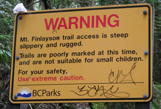
The next 1.3 km included over 300 m (1000 ft) of ascent. As you can imagine, this means that both hands and both feet were involved with a whole lot of panting and grunting too. The exposed rocks had smooth, rounded corners from the thousands of hiker footsteps over this popular route. It zigged and zagged to the summit, marked with race flagging as well as permanent reflective markers drilled into the granite.

I had been pushing myself up the steep and knew that I was going out too fast. I paused on an outcrop and let a group of four pass me so that I could re-boot at a more reasonable pace. I hit the summit just as my watch beeped my food reminder. Exactly 1.5 hours had already gone by.
The descent was not anything like the climb. We were sent down a wide, double track trail that dropped us somewhat more gradually. But even though we were descending, there were still countless uphill grunts that smacked us out of any mind-wandering trance. Eventually we popped out on a paved road where a sign let us know that we were entering the municipality of Highlands. We cruised this residential neighbourhood, entered the trails of Gowlland Tod Park and found our first aid station (approx 12 km).
The next section included an upsy-downsie climb up to Holmes Peak and then onto Jocelyn Hill. It was not as grueling as I had predicted from studying the elevation profile. Although it was generally uphill, there were many opportunities to run or shuffle along unexpected downhills. Holmes Peak (329 m) is graced with powerline towers and incredible views of the ocean below. Farther along, Jocelyn Hill (434 m) provides a more stunning view of the coastal fjords that we call home. Again we had climbed above treeline on this rocky outcrop and could enjoy the morning heat radiating from the granite surface. A group of volunteers were at the summit, recording race numbers, marking the turn-around point for the 25 km racers and enjoying the spectacular 360° view.
After some sweet downhill switchbacks and a few more unexpected uphill grinds, we dropped severely down to the beach at McKenzie Bight. Yes – the beach. Although the elevation profile says 17 m, I can attest to running just above the tidal mark on the beach trail. As I looked out over the water, I tried not to think about the 420 m (1360 ft) climb that lay ahead of me. I simply focused on shuffling up the almost runnable trail leading to aid station #2 (approx 24 km).
The 4.5 km climb from McKenzie Bight beach to the summit of Mt Work took me 50 minutes of hard effort. The trail surface varies from wide dual track with loose rocks to narrow, steep clambers to exposed granite ridge line. All of it was relentless. I was still pushing my pace here, knowing that I was the 5th women but trying to remind myself that the ‘race’ shouldn’t begin until the final quarter. Upon reaching the summit, the real work began. Flagging ribbon was difficult to follow since we were above the main tree line and there were so many small, off-shoot trails. I spent a lot of time standing around, searching for a ribbon. It was impossible to have any flow on this much needed downhill section. With so much climbing in my legs already, I dreaded the thought of adding more so I was extra careful to be certain of the correct route. Finally the steep descent eased and we had about 1 km of flat trail before arriving at aid station #3 (approx 29.5 km).
There were only 20 (+4) km left to go but I knew what was in store. There would not be a moment’s rest during any of this race. No easy miles. No ‘gimme’ clicks.
I love an out-and-back course since you get to see other runners, call out words of encouragement and receive them back. I exchanged words with every one of the racers as I returned to the summit of Mt Work and descended down the far side. In one steep, narrow gap, the tread of my shoe skidded on a light dusting of sand and I slid down a short face. In an instant, I was seeing stars due to a tweeked ankle. Passers-by and other racers stopped to ensure I was okay as I gingerly tested if it could bear weight. After a few steps and a few minute walk, I recognized that my ankle felt okay as long as my foot placement was flat. I wondered if I had seen any flat footing so far on course. I cautiously continued along and was eventually able to muster back some confidence in my stride.
As I expected, climbing up from McKenzie Bight beach back up to Jocelyn Hill was far more difficult on the return route. It was hotter, the legs were more fatigued and the climb was steeper on this side. Those 6 km took me 1hr 20min. And from there, the descent and climb back up to Holmes Peak really took a toll. At that point, I was out of fluids and course markings were becoming an issue. It seemed that the course had been flagged with an eye to the out-bound route. But, upon return, intersections would be flagged up until we reached them but there would be no indication of which way to continue at that intersection. With a lot of guesswork, some memory and sheer stubbornness, I pressed on. I reveled in the sulpher smell of the Cowichan Valley mill, knowing that the smell was only evident as we reached each summit.
When I finally arrived at aid station #1 again (approx 47 km), I was depleted. I had been without water for over an hour and I knew that I still had another huge climb ahead of me. I took a seat, drank almost a litre of water and watched as a young woman passed through, taking 5th place from me. I summoned up my strength to follow her for the final ~5 km of the course. Although we did not have to go over the top of Mt Finlayson again, the side trail still had a significant climb and steep descent. Luckily, I instantly felt better after my re-hydration and made a mental note to bring a third water bottle next year.
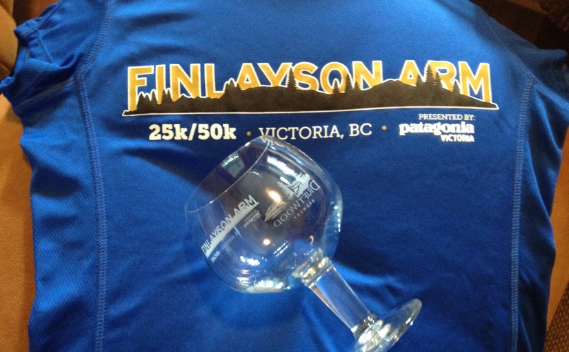
The 53+ km course was challenging right to the end. As I ran on rugged mountain bike trails alongside a golf course, I had no idea where the finish line would be. It was a huge relief when I finally spied our tent through the trees, still pitched in the group campsite and knew the finish line was right around the corner. As I crossed the finish line, I was greeted by RD Myke LaBelle who handed me my awesome finisher award – a Driftwood Brewery chalice.

This course is the most difficult, stand-alone 50 km I have run (except, perhaps, a certain Chris Scott-Ojai-C4P event). It has all the punch of a 50 miler, packed into 30 miles. Imagine if Mt Frosty, Squamish Chief and Mt Kusam had a love child – the love child would be Finlayson Arm 50 km.

Out of 56 starters, only 45 made it to the finish line within the tight 11 hour cut-off. Aid stations are few and far between since the route is so remote. Even so, in its first year, it is a stand-out event and I can’t wait to return to it next year, but I will prepare differently, knowing that it is a race with not a moment’s rest permitted.

Finish time – 8:30:28
21/45 finishers; 6/11 women; 1/3 40-49 age group
And here is the local paper write-up: Victoria Sports News
